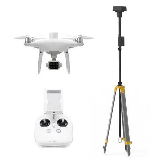
Phantom 4 Multispectral + D-RTK 2 mobile base station
Description
Gather precise plant-level data using the P4 Multispectral – a high-precision drone with a seamlessly integrated multispectral imaging system built for agriculture missions, environmental monitoring, and more.
An integrated spectral sunlight sensor on top of the drone captures solar irradiance, which maximizes accuracy and consistency of data collection through different times of day. When combined with post-processed data, this information helps to obtain the most accurate NDVI results.
Aircraft
-
Takeoff Weight
-
1487 g
-
Diagonal Distance (Propellers Excluded)
-
350 mm
-
Max Service Ceiling Above Sea Level
-
19685 ft (6000 m)
-
Max Ascent Speed
-
6 m/s (automatic flight); 5 m/s (manual control)
-
Max Descent Speed
-
3 m/s
-
Max Speed
-
31 mph (50 kph) (P-mode); 36 mph (58 kph) (A-mode)
-
Max Flight Time
-
Approx. 27 minutes
-
Operating Temperature
-
0° to 40° C (32° to 104° F)
-
Operating Frequency
-
2.4000 GHz to 2.4835 GHz (Europe, Japan, Korea)
5.725 GHz to 5.850 GHz (Other countries/regions)[1]
-
Transmission Power (EIRP)
-
2.4 GHz: < 20 dBm (CE / MIC / KCC)
5.8 GHz: < 26 dBm (FCC / SRRC / NCC)
-
Hover Accuracy Range
-
RTK enabled and functioning properly:
Vertical: ± 0.1 m; Horizontal: ± 0.1 m
RTK disabled:
Vertical: ± 0.1 m (with vision positioning); ± 0.5 m (with GNSS positioning)
Horizontal: ± 0.3 m (with vision positioning); ± 1.5 m (with GNSS positioning)
-
Image Position Compensation
-
The relative positions of the centers of the six cameras’ CMOS and the phase center of the onboard D-RTK antenna have been calibrated and are recorded in the EXIF data of each image.
Mapping Functions
-
Ground Sample Distance (GSD)
-
(H/18.9) cm/pixel, H indicates the aircraft altitude relative to the area mapped (unit: m)
-
Rate of Data Collection
-
Max operating area of approx. 0.63 km2 for a single flight at an altitude of 180 m, i.e., GSD is approx. 9.52 cm/pixel, with a forward overlap rate of 80% and a side overlap ratio of 60%, during a flight that drains the battery from 100% to 30%.
GNSS
-
Single-Frequency High-Sensitivity GNSS
-
GPS + BeiDou + Galileo[2] (Asia); GPS + GLONASS + Galileo[2] (other regions)
-
Multi-Frequency Multi-System High-Precision RTK GNSS
-
Frequency Used
GPS: L1/L2; GLONASS: L1/L2; BeiDou: B1/B2; Galileo[2]: E1/E5
First-Fixed Time: < 50 s
Positioning Accuracy: Vertical 1.5 cm + 1 ppm (RMS); Horizontal 1 cm + 1 ppm (RMS).
1 ppm indicates error with a 1 mm increase over 1 km of movement.
Velocity Accuracy: 0.03 m/s
Gimbal
-
Controllable Range
-
Tilt: -90° to +30°
Vision System
-
Velocity Range
-
≤ 31 mph (50 kph) at 6.6 ft (2 m) above ground with adequate lighting
-
Altitude Range
-
0 – 33 ft (0 – 10 m)
-
Operating Range
-
0 – 33 ft (0 – 10 m)
-
Obstacle Sensory Range
-
2 – 98 ft (0.7 – 30 m)
-
Operating Environment
-
Surfaces with clear patterns and adequate lighting (> 15 lux)
Camera
-
Sensors
-
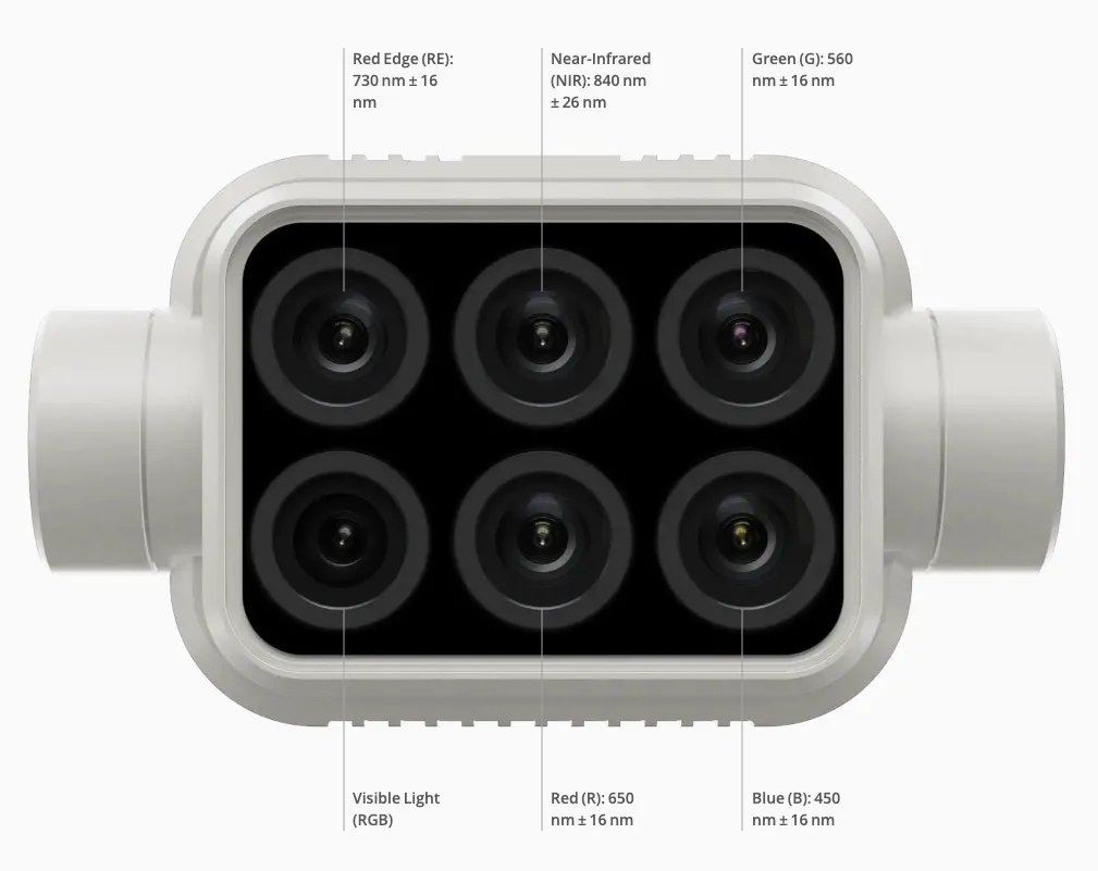
Six 1/2.9” CMOS, including one RGB sensor for visible light imaging and five monochrome sensors for multispectral imaging.
Each Sensor: Effective pixels 2.08 MP (2.12 MP in total)
-
Filters
-
Blue (B): 450 nm ± 16 nm; Green (G): 560 nm ± 16 nm; Red (R): 650 nm ± 16 nm; Red edge (RE): 730 nm ± 16 nm; Near-infrared (NIR): 840 nm ± 26 nm
-
Lenses
-
FOV (Field of View): 62.7°
Focal Length: 5.74 mm (35 mm format equivalent: 40 mm), autofocus set at ∞
Aperture: f/2.2
-
RGB Sensor ISO Range
-
200 – 800
-
Monochrome Sensor Gain
-
1 – 8x
-
Electronic Global Shutter
-
1/100 – 1/20000 s (visible light imaging); 1/100 – 1/10000 s (multispectral imaging)
-
Max Image Size
-
1600×1300 (4:3.25)
-
Photo Format
-
JPEG (visible light imaging) + TIFF (multispectral imaging)
-
Supported File Systems
-
FAT32 (£ 32 GB); exFAT (> 32 GB)
-
Supported SD Cards
-
microSD with a minimum write speed of 15 MB/s. Max Capacity: 128 GB. Class 10 or UHS-1 rating required
-
Operating Temperature
-
0° to 40° C (32° to 104° F)
Remote Controller
-
Operating Frequency
-
2.4000 GHz to 2.4835 GHz (Europe, Japan, Korea)
5.725 GHz to 5.850 GHz (Other countries/regions)[1]
-
Transmission Power (EIRP)
-
2.4 GHz: < 20 dBm (CE / MIC / KCC)
5.8 GHz: < 26 dBm (FCC / SRRC / NCC)
-
Max Transmission Distance
-
FCC / NCC: 4.3 mi (7 km)
CE / MIC / KCC / SRRC: 3.1 mi (5 km)(Unobstructed, free of interference)
-
Built-in Battery
-
6000 mAh LiPo 2S
-
Operating Current / Voltage
-
1.2 A @ 7.4 V
-
Mobile Device Holder
-
Tablets and smartphones
-
Operating Temperature
-
0° to 40° C (32° to 104° F)
Intelligent Flight Battery (PH4-5870mAh-15.2V)
-
Capacity
-
5870 mAh
-
Voltage
-
15.2 V
-
Battery Type
-
LiPo 4S
-
Energy
-
89.2 Wh
-
Net Weight
-
468 g
-
Operating Temperature
-
-10° to 40° C (14° to 104° F)
-
Charging Temperature
-
5° to 40° C (41° to 104° F)
-
Max Charging Power
-
160 W
Intelligent Flight Battery Charging Hub (PHANTOM 4 CHARGING HUB)
-
Voltage
-
17.5 V
-
Operating Temperature
-
5° to 40° C (41° to 104° F)
AC Power Adapter (PH4C160)
-
Voltage
-
17.4 V
-
Rated Power
-
160 W
GNSS Recevier
| GNSS Frequency | Simultaneously receive: GPS: L1 C/A, L2, L5 BEIDOU: B1, B2, B3 GLONASS: F1, F2 Galileo: E1, E5A, E5B |
|---|---|
| Positioning Accuracy | Single Point Horizontal:1.5 m(RMS) Vertical:3.0 m(RMS) RTK Horizontal:1 cm+ 1 ppm(RMS) Vertical:2 cm+ 1 ppm(RMS) 1 ppm: For every 1 km increase in distance, the accuracy will be 1 mm less. For example, the horizontal accuracy is 1.1 cm when the receiving end is 1 km away from the base station. |
| Positioning Update Rate | 1 Hz, 2 Hz, 5 Hz, 10 Hz and 20 Hz |
| Cold Start | <45 s |
| Hot Start | <10 s |
| Recapture Time | <1 s |
| Initialization Reliability | >99.9% |
| Differential Data Format | RTCM 2.X/3.X |
IMU
| Features | Built-in high-precision 6-axis accelerometer D-RTK 2 movement monitoring Sloping measurements Electronic bubble level |
|---|
Physical Characteristics
| Dimensions(D-RTK 2 body with extension rod) | 168 mm×168 mm×1708 mm |
|---|---|
| IP Rating | IP65 |
Communication and Data Storage
| Data Link | OcuSync, Wi-Fi, LAN, 4G |
|---|---|
| Operating Frequency | 2.400 GHz to 2.483 GHz (China, United States, Australia, Europe, Japan, Korea) 5.725 GHz to 5.850 GHz (China, United States, Australia) |
| EIRP | OcuSync 2.4 GHz SRRC (Mainland China) / CE (Europe) / MIC (Japan) / KCC (Korea): < 20 dBm FCC (United States, Australia) / NCC (Taiwan, China): < 26 dBm 5.8 GHz FCC (United States, Australia) / SRRC (Mainland China) / NCC (Taiwan, China): < 26 dBm Wi-Fi 2.4 GHz SRRC (Mainland China) / CE (Europe) / MIC (Japan) / KCC (Korea): < 20 dBm FCC (United States, Australia) / NCC (Taiwan, China): < 22 dBm 5.8 GHz FCC (United States, Australia) / SRRC (Mainland China) / NCC (Taiwan, China): < 22 dBm |
| Communication Distance | Operating Mode 1/3 SRRC/NCC/FCC/MIC/KCC/CE: 2 km (Unobstructed and free of interference, when the D-RTK 2 Mobile Station is used as a base station and the distance from the D-RTK 2 antenna to the bottom of the tripod is 1.8 m, when the difference in height between the remote controller and D-RTK 2 is less than 2 m, and when the remote controller is 1.2 m from ground level) Operating Mode 4 Operating Mode 5 |
| Memory Capacity | 16 GB |
Electrical Characteristics
| Power Consumption | 12 W |
|---|---|
| Power Supply | 16.5 to 58.8VDC |
| Battery | Type:Lithium-ion battery Capacity: 4920 mAh Energy: 37.3 WH |
| Run Time | WB37 battery:>2 h MG-12000P battery:>50 h |
Operating Temperature
| Operating Temperature | 4° to 131° F (-20° to 55° C) |
|---|

Description
Gather precise plant-level data using the P4 Multispectral – a high-precision drone with a seamlessly integrated multispectral imaging system built for agriculture missions, environmental monitoring, and more.
An integrated spectral sunlight sensor on top of the drone captures solar irradiance, which maximizes accuracy and consistency of data collection through different times of day. When combined with post-processed data, this information helps to obtain the most accurate NDVI results.
Aircraft
-
Takeoff Weight
-
1487 g
-
Diagonal Distance (Propellers Excluded)
-
350 mm
-
Max Service Ceiling Above Sea Level
-
19685 ft (6000 m)
-
Max Ascent Speed
-
6 m/s (automatic flight); 5 m/s (manual control)
-
Max Descent Speed
-
3 m/s
-
Max Speed
-
31 mph (50 kph) (P-mode); 36 mph (58 kph) (A-mode)
-
Max Flight Time
-
Approx. 27 minutes
-
Operating Temperature
-
0° to 40° C (32° to 104° F)
-
Operating Frequency
-
2.4000 GHz to 2.4835 GHz (Europe, Japan, Korea)
5.725 GHz to 5.850 GHz (Other countries/regions)[1]
-
Transmission Power (EIRP)
-
2.4 GHz: < 20 dBm (CE / MIC / KCC)
5.8 GHz: < 26 dBm (FCC / SRRC / NCC)
-
Hover Accuracy Range
-
RTK enabled and functioning properly:
Vertical: ± 0.1 m; Horizontal: ± 0.1 m
RTK disabled:
Vertical: ± 0.1 m (with vision positioning); ± 0.5 m (with GNSS positioning)
Horizontal: ± 0.3 m (with vision positioning); ± 1.5 m (with GNSS positioning)
-
Image Position Compensation
-
The relative positions of the centers of the six cameras’ CMOS and the phase center of the onboard D-RTK antenna have been calibrated and are recorded in the EXIF data of each image.
Mapping Functions
-
Ground Sample Distance (GSD)
-
(H/18.9) cm/pixel, H indicates the aircraft altitude relative to the area mapped (unit: m)
-
Rate of Data Collection
-
Max operating area of approx. 0.63 km2 for a single flight at an altitude of 180 m, i.e., GSD is approx. 9.52 cm/pixel, with a forward overlap rate of 80% and a side overlap ratio of 60%, during a flight that drains the battery from 100% to 30%.
GNSS
-
Single-Frequency High-Sensitivity GNSS
-
GPS + BeiDou + Galileo[2] (Asia); GPS + GLONASS + Galileo[2] (other regions)
-
Multi-Frequency Multi-System High-Precision RTK GNSS
-
Frequency Used
GPS: L1/L2; GLONASS: L1/L2; BeiDou: B1/B2; Galileo[2]: E1/E5
First-Fixed Time: < 50 s
Positioning Accuracy: Vertical 1.5 cm + 1 ppm (RMS); Horizontal 1 cm + 1 ppm (RMS).
1 ppm indicates error with a 1 mm increase over 1 km of movement.
Velocity Accuracy: 0.03 m/s
Gimbal
-
Controllable Range
-
Tilt: -90° to +30°
Vision System
-
Velocity Range
-
≤ 31 mph (50 kph) at 6.6 ft (2 m) above ground with adequate lighting
-
Altitude Range
-
0 – 33 ft (0 – 10 m)
-
Operating Range
-
0 – 33 ft (0 – 10 m)
-
Obstacle Sensory Range
-
2 – 98 ft (0.7 – 30 m)
-
Operating Environment
-
Surfaces with clear patterns and adequate lighting (> 15 lux)
Camera
-
Sensors
-
Six 1/2.9” CMOS, including one RGB sensor for visible light imaging and five monochrome sensors for multispectral imaging.
Each Sensor: Effective pixels 2.08 MP (2.12 MP in total)
-
Filters
-
Blue (B): 450 nm ± 16 nm; Green (G): 560 nm ± 16 nm; Red (R): 650 nm ± 16 nm; Red edge (RE): 730 nm ± 16 nm; Near-infrared (NIR): 840 nm ± 26 nm
-
Lenses
-
FOV (Field of View): 62.7°
Focal Length: 5.74 mm (35 mm format equivalent: 40 mm), autofocus set at ∞
Aperture: f/2.2
-
RGB Sensor ISO Range
-
200 – 800
-
Monochrome Sensor Gain
-
1 – 8x
-
Electronic Global Shutter
-
1/100 – 1/20000 s (visible light imaging); 1/100 – 1/10000 s (multispectral imaging)
-
Max Image Size
-
1600×1300 (4:3.25)
-
Photo Format
-
JPEG (visible light imaging) + TIFF (multispectral imaging)
-
Supported File Systems
-
FAT32 (£ 32 GB); exFAT (> 32 GB)
-
Supported SD Cards
-
microSD with a minimum write speed of 15 MB/s. Max Capacity: 128 GB. Class 10 or UHS-1 rating required
-
Operating Temperature
-
0° to 40° C (32° to 104° F)
Remote Controller
-
Operating Frequency
-
2.4000 GHz to 2.4835 GHz (Europe, Japan, Korea)
5.725 GHz to 5.850 GHz (Other countries/regions)[1]
-
Transmission Power (EIRP)
-
2.4 GHz: < 20 dBm (CE / MIC / KCC)
5.8 GHz: < 26 dBm (FCC / SRRC / NCC)
-
Max Transmission Distance
-
FCC / NCC: 4.3 mi (7 km)
CE / MIC / KCC / SRRC: 3.1 mi (5 km)(Unobstructed, free of interference)
-
Built-in Battery
-
6000 mAh LiPo 2S
-
Operating Current / Voltage
-
1.2 A @ 7.4 V
-
Mobile Device Holder
-
Tablets and smartphones
-
Operating Temperature
-
0° to 40° C (32° to 104° F)
Intelligent Flight Battery (PH4-5870mAh-15.2V)
-
Capacity
-
5870 mAh
-
Voltage
-
15.2 V
-
Battery Type
-
LiPo 4S
-
Energy
-
89.2 Wh
-
Net Weight
-
468 g
-
Operating Temperature
-
-10° to 40° C (14° to 104° F)
-
Charging Temperature
-
5° to 40° C (41° to 104° F)
-
Max Charging Power
-
160 W
Intelligent Flight Battery Charging Hub (PHANTOM 4 CHARGING HUB)
-
Voltage
-
17.5 V
-
Operating Temperature
-
5° to 40° C (41° to 104° F)
AC Power Adapter (PH4C160)
-
Voltage
-
17.4 V
-
Rated Power
-
160 W
GNSS Recevier
| GNSS Frequency | Simultaneously receive: GPS: L1 C/A, L2, L5 BEIDOU: B1, B2, B3 GLONASS: F1, F2 Galileo: E1, E5A, E5B |
|---|---|
| Positioning Accuracy | Single Point Horizontal:1.5 m(RMS) Vertical:3.0 m(RMS) RTK Horizontal:1 cm+ 1 ppm(RMS) Vertical:2 cm+ 1 ppm(RMS) 1 ppm: For every 1 km increase in distance, the accuracy will be 1 mm less. For example, the horizontal accuracy is 1.1 cm when the receiving end is 1 km away from the base station. |
| Positioning Update Rate | 1 Hz, 2 Hz, 5 Hz, 10 Hz and 20 Hz |
| Cold Start | <45 s |
| Hot Start | <10 s |
| Recapture Time | <1 s |
| Initialization Reliability | >99.9% |
| Differential Data Format | RTCM 2.X/3.X |
IMU
| Features | Built-in high-precision 6-axis accelerometer D-RTK 2 movement monitoring Sloping measurements Electronic bubble level |
|---|
Physical Characteristics
| Dimensions(D-RTK 2 body with extension rod) | 168 mm×168 mm×1708 mm |
|---|---|
| IP Rating | IP65 |
Communication and Data Storage
| Data Link | OcuSync, Wi-Fi, LAN, 4G |
|---|---|
| Operating Frequency | 2.400 GHz to 2.483 GHz (China, United States, Australia, Europe, Japan, Korea) 5.725 GHz to 5.850 GHz (China, United States, Australia) |
| EIRP | OcuSync 2.4 GHz SRRC (Mainland China) / CE (Europe) / MIC (Japan) / KCC (Korea): < 20 dBm FCC (United States, Australia) / NCC (Taiwan, China): < 26 dBm 5.8 GHz FCC (United States, Australia) / SRRC (Mainland China) / NCC (Taiwan, China): < 26 dBm Wi-Fi 2.4 GHz SRRC (Mainland China) / CE (Europe) / MIC (Japan) / KCC (Korea): < 20 dBm FCC (United States, Australia) / NCC (Taiwan, China): < 22 dBm 5.8 GHz FCC (United States, Australia) / SRRC (Mainland China) / NCC (Taiwan, China): < 22 dBm |
| Communication Distance | Operating Mode 1/3 SRRC/NCC/FCC/MIC/KCC/CE: 2 km (Unobstructed and free of interference, when the D-RTK 2 Mobile Station is used as a base station and the distance from the D-RTK 2 antenna to the bottom of the tripod is 1.8 m, when the difference in height between the remote controller and D-RTK 2 is less than 2 m, and when the remote controller is 1.2 m from ground level) Operating Mode 4 Operating Mode 5 |
| Memory Capacity | 16 GB |
Electrical Characteristics
| Power Consumption | 12 W |
|---|---|
| Power Supply | 16.5 to 58.8VDC |
| Battery | Type:Lithium-ion battery Capacity: 4920 mAh Energy: 37.3 WH |
| Run Time | WB37 battery:>2 h MG-12000P battery:>50 h |
Operating Temperature
| Operating Temperature | 4° to 131° F (-20° to 55° C) |
|---|
Reviews
Sign in to leave a review